| Gloucestershire Geodiversity Introduction 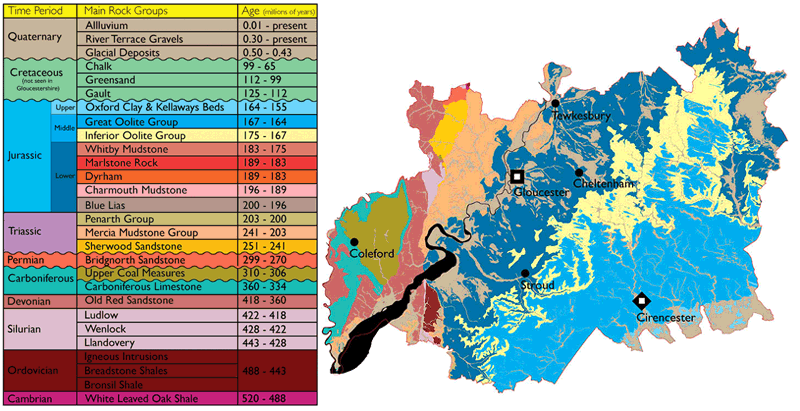 Gloucestershire contains some of the most varied geology seen within the U.K. This has given rise to a wide range of scenic features for which the county is renowned, including the escarpments of the Cotswolds and Forest of Dean, the outliers of May Hill and Robinswood Hill, the deep gorge of the Wye Valley, and the low-lying area of the Severn Vale. Gloucestershire contains some of the most varied geology seen within the U.K. This has given rise to a wide range of scenic features for which the county is renowned, including the escarpments of the Cotswolds and Forest of Dean, the outliers of May Hill and Robinswood Hill, the deep gorge of the Wye Valley, and the low-lying area of the Severn Vale.Draw a circle, 70 miles diameter, with Gloucester Cathedral at the centre, and the vast majority of the divisions of the geological column fall within it. In this respect, Gloucestershire is unique amongst all of the counties in the UK. Rocks from the Pre-Cambrian to present day alluvium are represented, extending back through time over 500 million years, with only the Tertiary and Cretaceous absent. However, the Cretaceous occurs just outside the county boundary, appearing just south of Swindon. To download a pdf of a more detailed stratigraphic table of Gloucestershire, click here... What is 'Geodiversity'? Geodiversity is the range of rocks, fossils, minerals and soils, it includes the processes that form these materials and the way that they shape and influence the landscape. This is not restricted to the natural landscape. The way in which rocks are used as building stones, the processes of extracting and exploiting the rocks and minerals from quarries mines and pits and how this has influenced settlement and industry are all a part of geodiversity. The geology and diversity of rock types within the county has had a very strong influence on its landscape, vegetation and wildlife, as well as on the industry and heritage of the people living there. The topography, scenery, soils and vegetation noticeably change as the underlying geology changes from one rock type to another across the county. The county is split roughly into two parts, both physically and geologically, by the River Severn. To the west lie thick sequences of older (Palaeozoic) rocks, while those to the east are composed of younger (Mesozoic) sediments. The uplifted and exposed Palaeozoic rocks of the Forest of Dean outcrop in the west of the county, while to the north west, the southern end of the Malvern Hills contains the oldest rocks in the county. To the east and south east lies the impressive escarpment of the Cotswolds, virtually a complete sequence through the Lower and Middle Jurassic periods. Between these areas lies the low-lying plain of the Severn Vale, the southern end of the Worcester basin. The geology here is predominantly of Permo-Triassic sandstones and Lower Jurassic clays. The diversity of rocks in Gloucestershire, can be used to help interpret the rock succession as a sequence of events and environments. Each rock unit contains clues to the type of environment in which it was deposited, and by piecing all the clues together, it is possible to see that, these environments have changed quite dramatically over a vast expanse of time. The climate and landscape of Gloucestershire as we see it today has not always been like this. Britain has not always been an isolated island; it once formed part of a super-continent called Pangaea, and plate tectonics have transported it from south of the equator to its present latitude. It has experienced fluctuations in sea level and climate changes between icehouse and greenhouse. The changes in ancient deposition environments and the associated rock types seen today, combined with past and current physical processes has produced the diversity of scenery and landscapes that can be seen in Gloucestershire. Continued research will help us to gain a better understanding of the geology beneath us and to unravel some of the still un-answered questions that remain regarding the geological evolution of the county and the rest of Britain. |

| Gloucestershire Geoconservation Trust. Registered Charity Number: 1115272. © 2024 All Rights Reserved. |